Waterhole Creek Bridge
As the Main Southern Line from Sydney to Albury was completed in the late 1870s attention turned to branch lines to serve the wider region through which the trunk line passed and in particular the Monaro district. Numerous routes were suggested and trialed until a line branching at Goulburn, through Bungendore. Queanbeyan, Michelago and Cooma was built in the late 1880s.

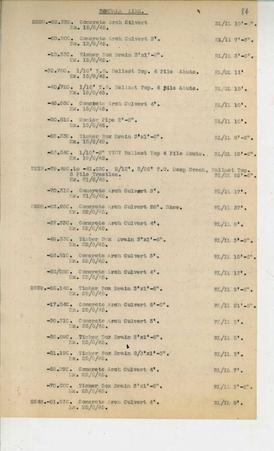
In particular, the section from Queanbeyan to Michelago was opened on 7 December 1887. It had been built by Alex. Johnstone & Co. to plans signed by John Whitton. All of the larger bridges on the line were of timber, including two laminated arches, three large truss bridges, numerous ‘Timber Openings’ and box culverts. The original John Whitton initialled Working Plan and Section also shows several 3ft and 4ft culverts, distinct from box drains. The intended material of construction of these waterways is not clear – brick or stone?
At a substantial watercourse, known as Waterhole Creek, not far north of Michelago, the plan showed three 26ft Timber Openings – that is a simple girder bridge of standard design. This bridge was not built however and at its location the crossing was made with a 20 ft (6m) unreinforced concrete arch. Whether this should be called a bridge or a culvert is debatable, but it is a substantial structure. Other culverts nearby shown as 3ft and 4ft span were also made of concrete.

Why the amendment was made is unknown and the source of the new design is only minimally documented. Specific plans for the bridge survive and they are clearly New South Wales Public Works Department, Railway Construction Branch plans, and are annotated as having been sent to Mr [Wiliiam] Hutchinson, later Chief Engineer, but at the time District Engineer, presumably for the relevant district. The plan has the name A Howarth in the margin, perhaps the designer or draftsman, but otherwise not known. With plans surviving of the bridge as it exists, pre-dating the opening of the line there can be little doubt that it was in place and working in 1887. Culverts do not have individual plans – just a page of standard details for the several diameters.
The title block on the plans specifies that it is to be concrete. Plans exist for a very similar bridge across Mullet Creek near the Up end of the Woy Woy tunnel north of Sydney, without specification of material, and that line came into use in 1888. The Mullet Creek bridge, still in service, is of sandstone. Both it and Waterhole Creek are near identical in design with buttresses integral with the arch ring at about 2 metre centres.
Previously it had been considered that the first use of unreinforced concrete in an arch bridge had been at Black Bobs Creek on the Hume Highway near the junction of the Illawarra Highway, known as Hoddles Crossroads. See a separate listing for the Black Bobs Creek bridge in this series. Unless and until any other older bridge can be identified the claim is made that Waterhole Creek Bridge is the first in NSW.
Use this link to read of Black Bobs Creek Bridge

The nearby concrete culverts while contemporary with the bridge are not the first use of concrete for culverts in NSW. Many such structures were built between Young and Cowra, and between Cowra and Blayney on the cross-country South to West link between Demondrille and Blayney. The section between Cowra and Blayney opened in February 1888, thus two months after the line to Michelago if such dates are to be adopted for the primacy of engineering features which had clearly been completed well before the first official train ran. The section from Young to Cowra had opened on 1 November 1886 and thus the culverts on that line, clearly shown on the Working Plan as ‘C Culverts’ or ‘C.C.’ predate the culverts near Waterhole Creek.
Some references on this subject include two 6.1m (20ft) concrete culverts, thus similar to Waterhole Creek, between Cowra and Blayney. Reference to the original Working Plan shows this to be a metrication error. ‘6’6” C.C.’ has been copied as 6.1m. There is no very large concrete arch culvert or bridge on the Blayney to Demondrille line.
Accessing the Bridge.
The railway line over the bridge is now closed. The railway and the Monaro Highway are parallel and close at this location, and the bridge can be seen from the road, on the left traveling south. It is not possible to stop at this place as the road is on an embankment, over Waterhole Creek, protected by guard rails leaving no safe place to pull off.
Between the railway and the present road, a former, now very abandoned, route of the Monaro Highway exists. The railway forms the border between NSW and the ACT for many kilometres to the north. The railway is in NSW; the western fence of the railway reservation is the border. Just north of Waterhole Creek the border leaves the railway and strikes sharply west, crossing the Monaro Highway which thus leaves the ACT and enters NSW. This location is clearly marked with road signs which are very close to the actual border. Immediately south, that is 250m, of the New South Wales sign a gravel track on the left junctions the highway and passes under the railway by means of a 26ft-timber-opening bridge which also spans Deep Creek.

Access to the Waterhole Creek Bridge may be had by parking on the wide gravel track and walking along the railway, or along the old road between the highway and the railway, or by driving along the abandoned highway route as far as one dares. Total distance to the bridge is 500m. The abandoned concrete road bridge across Deep Creek is in sound condition and trafficable. The road deteriorates markedly after a road maintenance stockpile site and would be difficult beyond for 2-wheel drive vehicles, especially in wet weather. At Waterhole Creek the road crosses on a timber bridge which is certainly no longer trafficable, though careful transit on foot is possible. The creek bed is deep with steep banks and is flooded so it is not possible to walk through the arch.


Waterhole Creek Bridge location map
References: Proposal to Nominate as Item of Engineering Heritage Interest, September 2025.